In the 19th century the section of the District of Columbia north of the former city of Georgetown was routinely referred to in the press as Georgetown Heights––a term that included locations well north of the city of Georgetown. Evidence of its use (which continued until the development and advertisement of new residential neighborhoods made it irrelevant) is not hard to find.
That the term included the highest point within the former city limits of Georgetown, which ran as far north as Fulton Street, should go without saying. In 1867, the house that once stood where the Russian Embassy is now was described as located “on the Heights of Georgetown on the west side of High Street… probably the most commanding site in the district, it being named Mount Alto.” This was confirmed when the owner of that house died, in 1875. “The funeral of the late Benjamin F. Hunt took place yesterday afternoon from his late residence on Georgetown Heights.”
(Georgetown Courier, May 25, 1867; “Georgetown,” Evening Star, July 2, 1875, p. 4)
“The most commanding site in the district” (also known as Pole Hill and Red Hill), was well-known for its sweeping panorama, and was frequently sought out by artists and photographers. Shortly before the Civil War, Titian Ramsay Peale (1799–1885) took this picture –– titled “View of Georgetown and Analastan Island from Georgetown Heights” –– from a point near what is now 2650 Wisconsin Avenue.
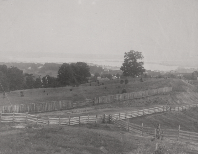
(Titian Ramsay Peale, circa 1860, Smithsonian Institution Archives)
Points west of Mount Alto were likewise considered to be on Georgetown Heights. In 1916 a watercolor painting, entitled “Old Georgetown Heights”, was reproduced in the Evening Star, showing the old house called Weston that stood at about the intersection of 36th Street and Massachusetts Avenue. The painter was Charles Henry Davis, Jr. (1845-1921), who had been Superintendent of the neighboring Naval Observatory.
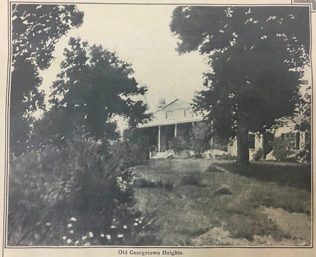
(“Watercolor Views of Washington,” Evening Star, November 19, 1916.)
In 1837 the property that is now the Naval Observatory was referred to as “Northview, Georgetown heights.” In 1811, when it was purchased by the federal government, it was described as “the Barber mansion, on Georgetown Heights.” “Bids were opened at the Navy Department today at noon for the construction of the new naval observatory building on Georgetown Heights.” Its official address was “U.S. Naval Observatory, Georgetown Heights, D.C.”
(“Public Sale,” National Intelligencer, November 18, 1837; “The New Observatory,” Evening Star, June 12, 1888, p. 3; Report of the Superintendent, United States Naval Observatory, Georgetown Heights, Washington, September 28, 1893)

“Superintendent’s Dwelling, U.S. Naval Observatory, Georgetown Heights, D.C.”
(Architectural drawing, Leon Dessez, 1891, US Naval Observatory Archives)
The term applied even further north. As early as 1829, the future location of the National Cathedral was described as being “on the heights above Georgetown,” and this was still the case in 1896, 1900, and 1903: “St. Alban’s Church, on Georgetown Heights”; “Mount Saint Alban, on Georgetown Heights”; “the Episcopal Cathedral on Georgetown Heights.”
(“For Sale,” National Intelligencer, June 15, 1829, p. 3; “St. Albans Church,” Evening Star, April 30, 1896, p.2; “Hearst Girls’ School: Bishop Satterlee Dedicates the New Structure.” Washington Post, May 25, 1900, p.7; “The News of Georgetown,” Washington Times, May 14, 1903, p. 4)
In 1842, “the farm and mansion called “The Retreat,” at what is now McLean Gardens, was advertised as “on the summit of the heights above Georgetown.” The same property was described thirty years later as “the college villa grounds, Georgetown heights.”
(“A Most Desirable Residence For Sale,” Daily Globe, July 16, 1842, p. 3; “Georgetown,” Evening Star, September 28, 1872, p. 5)
In 1845, “a small and select Boarding School” at the future site of Sidwell Friends School was advertised as “at the Highlands… on the heights above Georgetown.”
(“Female Education,” National Intelligencer, August 7-October 30, 1845, p. 4)
That the term applied to what is now Glover Park is amply confirmed.
In 1872, Michael Weaver, “perhaps the oldest butcher in the District” died “at his residence on Georgetown Heights,” opposite Holy Rood Cemetery.
In 1876 the Divine Science Church, at the intersection of Wisconsin Avenue and 35th Street was the “Mount Pleasant M. P. church, Georgetown heights.”
In 1904, the Evening Star reported that “Bertha L. Owens has begun construction of a handsome residence at the intersection of 32d and 37th streets, Georgetown Heights,” at what is now 2500 Wisconsin Avenue.
And, as late as 1926––and just a half a year before the first advertisements for Glover Park appeared––the apartment building at Wisconsin Avenue and W Place was advertised as “Georgetown Heights, Near Naval Observatory, 3507 W Place.”
(Georgetown Courier, January 27, 1872; “Excursions, Picnics, &C.,” Evening Star, July 31, 1876, p. 5; “Affairs in Georgetown,” Evening Star, May 19, 1904, p. 8; “Apartments, Etc.” Evening Star, March 13, 1926, p. 30)