“From Red Hill, which rises by pretty slopes at the rear of Georgetown, a fine view is had of the wide, winding river.” (Picturesque America, 1874) From the middle of the nineteenth century to the beginning of the twentieth, descriptions and images of the view from heights of Georgetown recur with a frequency that surprises, now that the view is obscured by houses and by trees.


Perhaps the oldest of image of the view from Georgetown Heights is a watercolor, from about 1820, “Prospect of Georgetown from the Tenleytown Road”, by Rebecca Wistar Morris Nourse (Collection of the National Society of The Colonial Dames of America). Nourse’s watercolor may represent the earliest image of upper Georgetown. The houses along the Tenleytown Road (i.e. Wisconsin Avenue) seen in the middle ground may be those of Lewis Kengla, Jacob Custard, and Michael Homiller. Beyond the houses and enclosures is the tree-crowned hill that was destined to become Holy Rood Cemetery. To its right, the Lombardy poplars on the southern flank of Georgetown College, and the building called Old North, are silhouetted against the Potomac River.

To modern eyes, the most baffling feature of Nourse’s painting is the foreground, a cut in the earth flanked by towering banks of exposed earth. The retaining wall of (what is now) the Russian Embassy may be a remnant of one of those banks, but where is the other? It would be tempting to assume that Nourse––who painted as a pastime––was being fanciful, were not the essential accuracy of her observation confirmed by another image, this time by a professional artist, the “View from the Cumberland Road near Georgetown”; again, the earth banks are shown flanking the road on both sides, and although they no longer loom quite as large as in the 1820 image, they do still appear to dwarf men on horseback. (Picture of the City of Washington and Its Vicinity for 1848 (Washington: William Q. Force, 1848) pp. 128-129; Morrison’s Stranger’s Guide to the City of Washington and its Vicinity, Washington, 1852, p.76.)

“The view is taken from the turnpike road leading from Georgetown to Fredericktown in Maryland. Nothing can surpass this splendid panorama. Below reposes the city of Georgetown with its spires––to the left is the Metropolis––like a waving band of silver, the Potomac stretches as far as the eye can reach to the south––while the cupola of Mount Vernon can be distinguished, in a clear day, by a good eye, breaking up against the southern horizon.”
(“View from the Cumberland Road near Georgetown”, Morrison’s Stranger’s Guide to the City of Washington and its Vicinity, Washington, 1852, p.76.)

“The condition of the principal street on the approach into your town, has for years past been discreditable to its authorities, and dangerous to those passing it. I allude to the deep cut, or red hill, which has long had a dangerous gulley, ten to twelve feet in depth on one side of the road, whilst an excavation for sand has been recently making on the other, and both without any protection for horse or carriage.” “The dangerous state of High Street Road near the Red Hill, is worthy of your early attention.” (Georgetown Advocate, June 12, 1847, p. 3; “High Street Road, Georgetown,” Evening Star, May 21, 1853, p. 3.)


The road cut at the crest can also be seen in the 1850 “View of the Morris Adler House and Georgetown Heights”, in which the artist (William H. Dougal) is looking north from the rear of his house at 3259 R Street in Georgetown. Exposed earth banks are visible along Wisconsin Avenue and 35th Street, and at the highest point of Wisconsin Avenue. In a detail, the cut at the top of the hill, similar to that in the two earlier views, can be seen. (To the right of the cut, silhouetted against the sky, is another prominent landmark, called the Signal Oak, which was cut down in 1916 to clear the path for Massachusetts Avenue. Records of the Columbia Historical Society, 9:209)
So what happened to the towering banks of exposed earth seen in these old images? In A Portrait Of Old Georgetown, the author observes that “the Wisconsin avenue hill” underwent a considerable reduction “just opposite where Mount Alto Hospital now stands, high on a hill which has been dug away.” In fact, the reduction extended considerably north and south of that point. ” The committee on legislation was directed to urge the District Commissioners to… provide for the removal of the hill on Tenleytown road between 37th street and Massachusetts avenue.” The improvement of the grade was a project that lasted for decades, and produced abundant material for street grading elsewhere. “Earth from Red Hill [was] laid down in various Georgetown streets.” The removal was also profitable in other ways: the 1865 Georgetown tax assessment states that the west part of lot 262 in Beatty & Hawkins’ Addition was “valuable for its loam used in foundries for casting”. Exposed earth is the rationale for at least one of the names by which the highest point within the corporate limits of Georgetown was known. “It is called Red Hill because of the color of its clay.” Not all of the exposed earth was red. “Part of lot 262, and all of lots 263, 264, and 300 on the Heights of Georgetown on the west side of High Street, containing some 17 acres, from which is now taken the celebrated yellow sand for government and other moulding purposes, probably the most commanding site in the district, it being named Mount Alto.”
(Grace Dunlop Ecker, A Portrait Of Old Georgetown, 1933, p.23; “Better Car Service––Cathedral Heights Citizens Declare For It”, Evening Star, October 24, 1902, p.16; “Cathedral Heights”, Washington Herald, September 18, 1910, part 3, p.4; Georgetown Courier, February 18, 1871, August 13, 1870; Washington Star, Sept. 30, 1915; Georgetown Courier, May 25, 1867)


At the beginning of the Civil War the panoramic view extolled in the Stranger’s Guide to the City of Washington acquired military significance when the Chief Signal Officer of the Union army chose Red Hill, from which one could see twenty miles into Virginia, to anchor a network of signal stations at high points up and down the Potomac River (see the Signal Camp, and The Signal Camp in Pictures).
An artist’s conception of the view from the Signal Camp shows a Union signal officer reading incoming wig-wag messages through his telescope, while an enlisted man with his signal flag stands ready to send a reply. (To convey the excellent view to be had from the heights the artist has conflated two different points of view, and the result, though dramatic, is impossible.)

“From Red Hill, which rises by pretty slopes at the rear of Georgetown, a fine view is had of the wide, winding river. The Potomac, just below, takes a broad sweep from west to east: and, at the place where it is spanned by the famous Long Bridge, over which the troops passed from Washington to their defeat at Bull Run, it seems to form almost a lake. Washington itself is descried between the trees from the east of Red Hill; in the dim distance, the shore of Maryland, lofty in places, and retreating southeastward; and, on the immediate right, the more attractive Virginian shore, with a glimpse of the historic estate of Arlington. A large aqueduct connects Georgetown with this Virginian shore; and the views from every point of it are full of attractive interest. Now the Potomac is just below you; its stream not so turbidly yellow as it becomes farther down. The Capitol, white and majestic, looms high above the metropolis, the rest of which seems a confused mass of houses and spires; verdant meadows, pastures, and natural lawns, sweeping down by gentle inclinations beneath elms and oaks…”
(Picturesque America, vol.II, William Cullen Bryant (ed.), 1874, p. 571. Thanks to Sue Rainey, author of Creating Picturesque America: Monument to the Natural and Cultural Landscape, 1994)


The 1874 “View from Red Hill, back of Georgetown” appears to represent a view from a point uphill of the road cut, and on the other side of the road. One of the two venerable trees in the foreground may correspond to the Signal Oak in the Dougal painting from a quarter century earlier. Just to its right, a structure with ventilation cupola, nestled low in trees, may be a house or a barn at Greenwood, at about 36th and Davis Street, which had a dairy; this would explain the cows in the foreground. As earlier, in Nourse’s 1820 view, a line of trees is silhouetted against the river at Georgetown College; and to their left, between a dark stand of trees and the water’s edge, the ornamented brick dome of the High Service Reservoir, at the southeast corner of Wisconsin Avenue and R Street, is recognizable.


“View of Georgetown and Analastan Island from Georgetown Heights”, is a photograph taken by Titian Ramsay Peale, circa 1860 (Smithsonian Institution Archives). Peale’s vantage point appears to have been at the crest now occupied by the Russian Embassy, and the distant landmark to which the caption refers is now known as Theodore Roosevelt Island. Bearing in mind the differences between photographs, dispassionately recording light and shadow, and illustrations, in which the artist is free to pick out details, it is nonetheless evident that the 1860 photograph has much in common with the 1874 “View from Red Hill, back of Georgetown”, including the venerable trees in the foreground, the High Service Reservoir, immediately to the left of the larger tree, and the structure with ventilation cupola––possibly a dairy barn at Greenwood. (The house to the left of the reservoir, in the middle of the gap between the trees, is that of the artist who painted the 1850 “View of the Morris Adler House and Georgetown Heights”.)
(Julie Link Haifley, “Capital Images: The Photography of Titian Ramsay Peale, 1855-1885”, Records of the Columbia Historical Society, vol.50 (1980) pp.229-244; John Cassin, Atlas: Mammology and Ornithology, 1858).


In 1890, when John W. Thompson subdivided thirty-four acres of elevated land north of what is now the Russian embassy, he avoided mention of anything that would have competed with his new designation––Tunlaw Heights––but made sure to allude to the celebrated view.
“Nature’s Beauty Spot––An Attractive and Rapidly-developing Suburb of Washington.––Tunlaw Heights and Vicinity––Unsurpassed as to Situation, Being on the Highest Ground in this Region––A Panorama Upon Which Thousands of Tourists Have Gazed with Admiration.”
(Washington Post, June 15, 1890, p.9)


A 1914 view of Washington––erroneously catalogued as taken from American University––is more likely to have been taken from the Tunlaw Towers, the Richard Goldsborough house at the northwest corner of Garfield Street and Wisconsin Avenue (“To Occupy the Goldsborough Mansion”, Washington Post, April 8, 1896, p.3). Although the location is further north than that of the earlier views, the higher vantage––from the roof, or an upper window, to judge by the telegraph pole––means that the prospect remains essentially the same. In the middle ground, the Naval Observatory, the Industrial Home School, and its schoolhouse (now Guy Mason Center), are easily identifiable, and to the right of the twin cupolas of the Industrial Home School, the Dougal House, now framed by trees, is still visible.
Even at ground level the view to had from a point on Wisconsin Avenue a half a block north of Garfield was enough to inspire an impassioned plea for its preservation by James Bryce, British Ambassador to the United States (1907–1913).
The Most Beautiful View of Washington is Threatened.
May I mention a point of view that is now threatened and perhaps almost gone? You all know the spot at which Wisconsin Avenue intersects Massachusetts Avenue, which has now been extended beyond that intersection into the country. At that point of intersection, just opposite where the Episcopal Cathedral is to stand, there is one spot commanding what is one of the most beautiful general views of Washington. You look down upon the city, you see its most striking buildings––the capitol, the Library, State, War, and Navy Department, and the Post-Office and other high buildings along Pennsylvania avenue––and beyond them you see the great silvery flood of the Potomac and the soft lines fading away in dim outline in the far southeast. It is a delightful and inspiring view.
All that piece of land is being now cut up, and according to present appearances houses will be built there immediately, and after two years nobody will ever see that view again except from the tower of the cathedral when erected. Can it be saved?
There may be other views of Washington that are as good, but there is none better. It is a view that speaks not only to the eye, but to the imagination also. The top of the slope ought to have been turned into a public park, and the houses below kept at such a height that if they were to be built they would not obstruct the view from above.
(James Bryce, “The Nation’s Capitol, An address to the Committee of One Hundred on the Development of Washington, D.C.,” National Geographic Magazine, Volume 24, 1913, pp. 737-750; “Lauds Beauty of City: Ambassador Bryce Points Out Needs of the Future,” Washington Post, February 28, 1913, p. 1)
As Bryce had foreseen, residential development––and in particular, the trees planted to shade those streets––soon restricted the view.
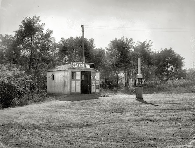
As for his favorite vantage, in 1917 a filling station was built on the triangle formed by the intersection of Garfield Street and Massachusetts and Wisconsin Avenues. When the property was zoned residential in 1920, the station, which was nonconforming, could not be improved, and fell into disrepair. In 1958 the National Capital Planning Commission filed a declaration of taking. After three attempts in Congress to be exempted from the zoning regulations, the American Oil Company gave up in 1959. In 1965 Princess Margaret dedicated a plaque honoring Ambassador Bryce in the park that succeeded the gas station.
(“Zoning Hassle Going to Court”, Washington Post and Times Herald, October 4, 1958, B2; “Amoco Drops Embattled Oil Station,” Evening Star, June 2, 1959, p. 2; “Princess to Dedicate District Park,” Evening Star, October 17, 1965, p. 1; “Princess Dedicates a Park,” Evening Star, November 17, 1965, p. 1.)
For the various names by which the high point, and the surrounding area, were known, see Pole Hill, Red Hill, Mount Alto and Georgetown Heights.
Thanks to Jerry McCoy, of the Peabody Room, Georgetown Branch Library, for drawing attention to these images.