• Skip to main content
  • Skip to after header navigation
  • Skip to site footer

Glover Park History

Historical Sketches of Glover Park, Upper Georgetown, and Georgetown Heights by Carlton Fletcher

  • Neighborhood
    • Neighborhood Histories
    • Neighborhood Images
    • Family Album
    • Oral History and Reminiscences
    • Residential Development Before 1926
    • Residential Development Since 1926
    • Investors & Developers
  • Population
    • Settlement
    • Kinds of Work
    • Settlers
    • Slavery
  • Geography
    • Maps, Places & Features
    • Streets
  • Estates & Farms
    • Alliance Farm
    • Burleith
    • Cedars
    • Clifton
    • Greenwood
    • Hillandale
    • Mount Alto
    • Normanstone
    • North View
    • Tunlaw Farm
    • Weston
  • Institutions
    • Former Institutions
    • Present Institutions
  • Cemeteries
    • Burial Grounds of Georgetown
    • Holy Rood Cemetery
    • Buried in Holy Rood
  • Civil War
    • The Civil War on Georgetown Heights
    • Local People in the Civil War
  • Appendix

Welcome to Glover Park History

A Brief History of Glover Park,

And the adjacent neighborhoods,

Cathedral Heights and Burleith,

And of the

Estates and Farms

of what was formerly known as

Georgetown Heights

With notes on

Prehistory, Land Tracts, Settlement, Occupations

Slavery, Civil War and Emancipation

And on former institutions, such as the 

Georgetown Poor House, the Colored Home, and the Industrial Home School

And the history of Holy Rood Cemetery and the people buried there,

such as

Joseph Nevitt, Henrietta Steptoe, and Susan Decatur

And notes on

Family History

and

Oral History and Reminiscences

Photographs and Maps

Related Resources

  • Aerial Map of Washington, 1922
  • Bygone Brookland
  • DC History Resources
  • Ghosts of DC
  • Historical Data on DC Buildings
  • Streets of Washington
  • Tenleytown History
  • Washington Directory, 1858


Introduction

A comparison of old and new maps shows that the city of Georgetown formerly reached as far north as what is now the Russian Embassy, and that the surrounding area, once known as Georgetown Heights, was still primarily agricultural.

Georgetown and parts of Washington County, Topographical Map of the District of Columbia, surveyed in the years 1856-1859 by Albert Boschke, (detail).
The city of Georgetown and adjacent parts of Washington County, as seen in a detail of the Topographical Map of the District of Columbia, surveyed in the years 1856-1859 by Albert Boschke.
The northern boundaries of the city of Georgetown, as confirmed by Congress––”An Act Amending the Charter of Georgetown,” March 3, 1809––are shown in red on a modern street map. (Prepared by Col. Robert B. Curtiss, of the Burleith Citizens Association in 1974.)
The northern tip of the former city of Georgetown was near the present intersection of Tunlaw Road and Fulton Street.  (Map by Robert B. Curtiss, 1974.)

The earliest institution of the neighborhood was the Georgetown Poorhouse, which stood just east of what is now Guy Mason Recreation Center, and was in operation from 1832 to 1875; after which it became the Industrial Home School, which closed in 1954.

The Poor and Work House of Georgetown.  (“Roadside Sketches”, Evening Star, August 15, 1891)
The Poor and Work House of Georgetown. (“Roadside Sketches”, Evening Star, August 15, 1891)

The oldest surviving institution is Holy Rood Cemetery, which also dates to 1832. The last resting place for seven thousand white and black Catholics of Georgetown, Holy Rood includes the best-documented slave burial ground in the District of Columbia, and the grave of Joseph Nevitt, a Minuteman of the American Revolution.

Holy Rood Cemetery in 1950, before the cobblestones were covered with asphalt. (Historical Society of Washington)
Holy Rood Cemetery in 1950. (Historical Society of Washington)

During the Civil War the Signal Corps trained on the heights overlooking Georgetown; Northern women founded the Colored Home and the Industrial Home School; and the earliest known photographs of the neighborhood were taken.

The Signal Camp of Instruction, 1861. (Miller’s Photographic History of the Civil War , 1911)
The Signal Camp of Instruction, 1861. The photographer appears to have set up his camera north and west of the present intersection of Calvert Street and Tunlaw Road. In the distance beyond the encampment the landmarks include Trinity Church Upper Burial Ground, Back Street, and The Cedars––corresponding to the present Holy Rood Cemetery, Tunlaw Road, and Duke Ellington High School. (Miller’s Photographic History of the Civil War , 1911)
Looking south from Red Hill; there appear to be two sheep in the foreground. (Carlisle Military Institute)
“The Signal Camp of Instruction, Red Hill, Georgetown, D.C.”   The prominent house in the distance is Richard S. Cox’s “Burleith”, and to its right, farther away, Georgetown College. (U.S. Army Heritage and Education Center at Carlisle Barracks)

Images of the military activity on the heights overlooking Georgetown reveal the open look of the land in the 19th century, when the neighborhood was dominated by the operations of a syndicate of master butchers, the suppliers of meat to the markets of Georgetown and of Washington City, who accumulated most of the land that was to become Glover Park.

After the Civil War the butcher’s syndicate of Georgetown­­ had to adjust to changes in their industry. As more livestock was arriving, by rail, on the other side of the city, the cattle market, stock pens, and slaughterhouses on this side of the city became increasingly irrelevant. At the same time, suburban land tracts on the periphery of the former cities of Washington and Georgetown, formerly devoted to agricultural use, were beginning to be developed for residential use. The butchers owned a considerable amount of open land at the northern end of Georgetown, and its increased value, once they ceased conducting their operations on it, and freed it for other use, was obvious to them.

Joseph T. Kengla and family, circa 1881 (detail). (Courtesy of a descendant.)
Joseph T. Kengla and family, circa 1881. Kengla, a dealer in beef, lamb, veal and mutton, lived at about 2320 Wisconsin Avenue, where the Sheffield Condominium is today.  (Photo courtesy of a descendant.)


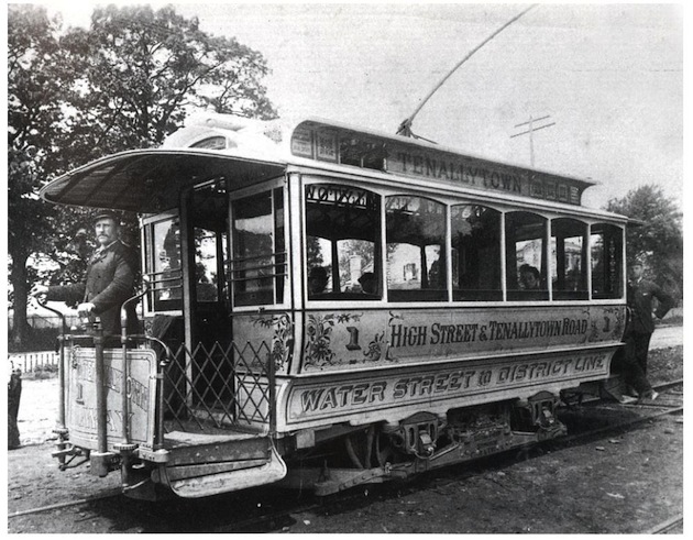
Joseph Weaver, Jacob H. Kengla, and Benjamin F. Hunt, who were among the most prosperous of the Georgetown butchers, took steps to enhance the residential potential of their real estate by incorporating a streetcar line between Georgetown and Tenleytown.

Conductor Terrance Sellers on the open platform of car No. 1 of the Georgetown & Tenallytown Street Railway. (Photo courtesy of Mike Copperthite)
The Georgetown & Tenallytown Street Railway, circa 1890, on what is now Wisconsin Avenue. (Photo courtesy of Michael C. Copperthite.)


Much of the present neighborhood was acquired in 1907 from the estate of Henry Kengla by the banker Charles Carroll Glover. The earliest advertisements to use the name Glover Park were placed in 1926.

Charles Carroll Glover (1846-1936), President of Riggs Bank.


This project has been generously supported by District of Columbia Advisory Neighborhood Commission 3B.

My thanks to Commissioners Brian Cohen and Mary C. Young, and to Danna McCormick, of DLM Web Development.

I have benefitted from the generosity of many historians, and am indebted to the patience and resourcefulness of many archivists and reference librarians, and in particular, to those of the Washingtoniana Division of Martin Luther King Library.

This work is dedicated to the memory of Robert W. Lyle (1922-1996) of the Peabody Room of the Georgetown Branch Library, who first guided me to the records of the part of Georgetown that is now in Glover Park.

 Carlton Fletcher

Questions and corrections may be directed to moc.yrotsihkraprevolg@notlrac
The citation and acknowledgement of my research is greatly appreciated.
The support of the Advisory Neighborhood Council (3B) is gratefully acknowledged.

Copyright © 2025 · Glover Park History · All Rights Reserved