While the eastern part of the present neighborhood was originally the northern extension of the city of Georgetown––an area dedicated to butchering and market gardening––the western part comes primarily from land purchased by banker Charles C. Glover from the estate of the butcher Henry Kengla. Residential development, fitful at first, took off in 1926, when the name Glover Park first appeared in print.
(What follows is an overview of the rest of this website. For more complete information, as well as for all sources, citations and photo credits, please see the relevant articles.)
Early Real Estate
Glover Park, west of Huidekoper Place, comes out of the 17th century land grant called Salop, which was later part of Alliance. East of Huidekoper Place, Glover Park comes out of Salcom, which was later called Knave’s Disappointment. Knave’s Disappointment, in turn, went into the 1769 Beatty and Hawkins’ Addition to Georgetown, by which the city of Georgetown was enlarged by three hundred lots. Of those, the fifty on either side of Wisconsin Avenue, from R Street north to Davis Street, and west to Huidekoper Place, constituted the northern extension of the corporation of Georgetown. (For additional information, see Land Tracts.)

The northern boundaries of colonial Georgetown were confirmed by Congress––”An Act Amending the Charter of Georgetown,” March 3, 1809––and are shown in red on a 20th century street map.

A detail of the 1814 Fenwick map of the Beatty and Hawkins’ Addition to Georgetown, showing the northern extension of the city of Georgetown. Back Street, West Street, Fayette Street, and High Street Continued correspond to the present Tunlaw Road, Whitehaven Parkway, 35th Street, and Wisconsin Avenue.
Settlement
Because the eastern part of Glover Park falls within the northern extension of Georgetown, the earliest record of the settlement of the neighborhood that preceded Glover Park is preserved in the municipal records of that city.
The earliest settlers of this neighborhood––Peter Colter, a German immigrant, and Murray Barker, a free black man––appear in Georgetown tax assessments between 1808 and 1810. Colter and Barker raised families along what is now Wisconsin Avenue, in the village of Wilberforce, a long-forgotten subdivision of Georgetown, and both supported themselves, in part, by growing produce for the local market. For a newly arrived immigrant, or a newly freed slave, with only a small amount of land to work with, market gardening made sense.
In general, the early population of upper Georgetown consisted of native-born whites (quite often from Pennsylvania), immigrants (from Germany and Ireland), and African Americans (both free and slave).

Upper Georgetown in the census of 1820 (page 52/162).
The census of 1820 affords the earliest glimpse of the settlers of the northern extension of Georgetown. Although some families present in 1820 are gone by 1830, long-time residents of Upper Georgetown are represented by “Free White” heads of family Michael Weaver, Murray Barker, Peter Coulter, Jacob Custard, and Lewis Kengla (which was spelled Canley on this occasion).
The “Free Colored” families living primarily in the village of Wilberforce, east of Wisconsin Avenue, are represented here by Clarissa Jenkins, John Swan, John Vincent, John Brown, Fanny Wilkins and Jared Hopkins.
In 1820 the number of slaves in Upper Georgetown––which would reach about 114 by 1862––was five, of whom two were members of families headed by John Brown and John Vincent, who were free.
Holy Rood Cemetery

Holy Rood Cemetery––originally, Trinity Church Upper Grave Yard––is the most historic institution in Glover Park. Consecrated in 1832, it is the last resting place for seven thousand Catholics of Georgetown, black and white.
The best-documented slave burial ground in the District of Columbia is located in the northwestern section of the cemetery, where no marker is to be seen.
In the oldest part of the cemetery, at its western edge , is the grave of Joseph Nevitt, a Minuteman of the American Revolution.
Some tombstones in Holy Rood bear names associated with the Catholic settlement of Maryland: Belt, Caperton, Clements, Dorsey, Magruder, Mattingly, Ritchie, Semmes, Tayloe, Queen––as well as many names of later arrivals––Cassel, Dreisch, Ehrmantraut, Everard, Harbaugh, Hein, Heiss, Holtzman, Kleindienst, Krouse, Ludecke, Perna, Piperno, Ricciardi, Ruppel, Scala, Stahl, Stohlman, and Vogt.
The numerous tombstones that record Irish origins include many that read “a citizen of Georgetown, D.C., but a native of Ireland”: Bennett, Cassidy, Conroy, Gallagher, Harvey, Hillis, Holleran, Horrigan, Kelley, Liden, Meany, McGuire, McMahon, O’Day, O’Gannon, O’Neale, O’Reilly, Power, Rielly, Ryan, and Shea.
Antebellum Georgetown’s free black citizens are represented by the Barker, Becraft, Belt, Butler, Chandler, Coquire, Dodson, Dorsey, Dover, Hawkins, Henson, Jackson, Lee, Ridgely, Queen, Shorter, Smackum, and Thomas families, among others.
Surnames of the slaves buried here include Beall, Boarman, Butler, Cooper, Countee, Crane, Gordon, Haven, Johnson, Lee, Madison, Montgomery, Nolan, Smallwood, Smith, and Thomas.

Joseph Nevitt, a Minuteman of the American Revolution, is buried at the western edge of Holy Rood.

The gravestone of a Civil War veteran, Pvt. Peter McGirr, Company K, 23rd Pennsylvania Infantry (Birney’s Zouaves), who died in 1899. (Section 55)
The Poor House of Georgetown

Between 1832 and 1875 the city of Georgetown maintained its Poor and Work House in the northern extension of the city limits, about where the Guy Mason Recreation Center is today. Despite the fact that it was funded by a philanthropic bequest, and had been intended as a charity, the frugal city fathers of Georgetown were unable to resist the temptation to economize by consolidating, under one roof, charity for the poor, and chastisement for the minor criminal, which they expressed with disarming candor: “The whole process of punishing the petty criminal offender and vagrant and protecting the unfortunate Poor of Town, may be connected within one general enclosure and under the same Superintendance.“

By 1898, all that remained of the Georgetown Poor and Work House was the central, white-washed wing of the Industrial Home School, which stood just east of what is now Guy Mason Recreation Center.
The Boschke Map

A detail of the Topographical Map of the District of Columbia, surveyed by Albert Boschke in the years 1856-1859.
Of the many maps that shed light on the development of the neighborhoods of Washington, perhaps the best is the Boschke map of 1859, which shows four property owners in the heart of what is now Glover Park.
Charles Homiller, whose house stood near Fulton Street and Tunlaw Road, was a master butcher, with a slaughterhouse, and sixty acres of land. During the Civil War, Homiller entertained Union officers at his house (with meals prepared by his slaves).
Henry Kengla, unmarried, was a wealthy master butcher who lived at what is now the northwest corner of Tunlaw Road and Benton Street. When Kengla died in 1906, at age 91, he had accumulated much of the land that would form the basis of Glover Park.
The Dashiell family, whose house stood at about 39th and Calvert, lived on a farm, but were not farmers. George Warren Dashiell was a Treasury clerk. In 1847 his nephew, Thomas Grayson Dashiell, inherited the farm; the 1850 census lists the twenty-year-old divinity student as the head of household. His retired father, who had also been a Treasury clerk, lived with him. In 1859, when the father died, Rev. Dashiell sold out to Jacob and Lewis Kengla, and went into the ministry in Richmond.
James Britt (whose house stood at about 39th Street, just north of W Street) was assessed in 1855 for 33 acres, two wagons, two horses, and a cow. Robert Britt, his son, listed in censuses as a gardener, eventually sold this land to Henry Kengla.
East of Wisconsin Avenue, the retired Bavarian engraver Conrad Schwarz lived just north of the bracket shaped Georgetown Poor House, near the present-day intersection of Edmunds and 36th Streets). Schwarz owned 84 acres of land, a horse, a cow, and a slave, Ellen Amelia Thomas, who had six children.
South of Schwarz, on the tract of land that is now the Naval Observatory, lived Margaret Barber, a genteel widow who was the second-largest slaveholder in the District of Columbia.
The Civil War on Georgetown Heights
During the Civil War the Signal Corps trained on the heights overlooking Georgetown; Northern women founded the Colored Home and the Industrial Home School; and the earliest known photographs of the neighborhood were taken.

A Highlander from New York City, 1861.
The 79th New York “Highlanders” were a volunteer militia regiment, sponsored by the Caledonian Society of New York City, and chartered in 1859. In 1861 the 79th was one of the first state militia regiments to answer Lincoln’s call to defend Washington. Initially encamped at Georgetown College, the 79th set up their second camp––christened Camp Lochiel––about where the Russian embassy is today.
There the New Yorkers were befriended by James H. Causten, whose country house Weston was on the other side of Wisconsin Avenue. Causten was a fervent Union man, and the war, barely started, had already exacted a price: his son had been in rebel hands for a month, one of the first Union prisoners of the war.
The “Highlanders” were in this neighborhood less than a week: “The 79th left camp yesterday afternoon and marched over the acqueduct to Virginia.” (Star, July 6, 1861).
A few weeks after the New York regiment’s departure, soldiers detailed from other branches of the military arrived to take their place on the hill overlooking Georgetown, and Camp Lochiel was renamed as the Signal Camp of Instruction.
The Army Signal Corps, founded here in the first year of the Civil War, proved its worth in the war, and went on to play a major role in the development of military communications, intelligence, and aviation, as well as in national weather reporting.

View of the Signal Camp of Instruction from Red Hill, 1861.

Taken on the same day as the previous image, looking South from Red Hill. At right, a farm house, at about 39th and W Streets.

The photograph of the “Signal Camp of Instruction, near Georgetown, D.C.”––taken in the fall of 1861 by Mathew Brady, or one of his assistants––shows a group of officers, including Maj. Albert J. Myer, Chief Signal Officer of the Army (seated, double row of buttons); behind him, with a full beard, Lt. Benjamin F. Fisher.

The Signal Camp hospital, on the occasion of the closing of the Signal Camp, August, 1865. Col. Benjamin F. Fisher, Chief Signal Officer of the Army, is seated in front of the whitewashed tree. The seated man to his left, wearing a white vest and a civilian coat, is his predecessor, Albert J. Myer, who had been relieved of his command.

Flag Lowering at the Signal Camp, August 1865. Albert J. Myer (seen grasping the lowered flag) is not in uniform because competition with the Secretary of War for control of military telegraphy had cost him his command. At far left, hand tucked in coat, is Benjamin F. Fisher, who escaped from a Confederate prison in 1864.

Henry Kengla’s compensation claim for slaves freed in 1862 (when about 15 white families in upper Georgetown and adjoining parts of Washington County owned about 120 slaves).

Mary Ann Clark (who lived near where Carillon House is today), appears to have derived a part of her living from hiring out her slaves to work in other households. In 1862 she filed for compensation for sixteen slaves.

The National Home for Destitute Colored Women and Children, at Burleith, 1864. The Home was a response to the crisis of orphaned refugee slaves in Washington, and was managed by committees of Northern women. It was established in the confiscated house of a Treasury Department official who had left Washington to serve in the Confederate government.
The Methodist Church
The oldest structure in Glover Park is the former Methodist Protestant chapel at 35th Street and Wisconsin Avenue, which was built in 1874. Its original clapboard later acquired a covering of pebble-dash stucco, and its name, Mount Pleasant Chapel, was changed to Mount Tabor Church. It was renamed Saint Luke’s United Methodist Church in 1946, and the congregation moved to its present home in 1954.

Mount Pleasant Methodist Protestant Chapel, Fayette and High Streets (35th and Wisconsin), 1874.

Mount Tabor Methodist Protestant Church, as it appeared between 1888 and 1913.

Two girls at Mount Tabor Church, circa 1915.

Mount Tabor Church in 1941.

In 1946 Mount Tabor Church, at 35th Street and Wisconsin Avenue, became Saint Luke’s United Methodist Church (seen here, circa 1950).

In 1954 the congregation of Saint Luke’s United Methodist Church left 35th Street and Wisconsin Avenue, and moved to their present location at 3655 Calvert Street; although a much larger church had been contemplated, it was scaled back during construction. Circa 2004 the church sold the unused portion of its land, and the view above (seen here in 1994) is now dominated by the Georgetown Heights Condominiums.
The Master Butchers
During much of the 19th century the neighborhood was dominated by a syndicate of master butchers, the purveyors of meat in the markets of Georgetown and of Washington City. Although their initial purchases of real estate were modest, the master butchers eventually accumulated almost all of the land that was to become Glover Park.

After the Civil War, Benjamin F. Hunt, a member of the Georgetown syndicate of master butchers, built his house on a parcel of land called Mount Alto––but the highest point in the municipal boundaries of the city of Georgetown was more commonly called Pole Hill or Red Hill.

Joseph T. Kengla and family, circa 1881. The house (at what is now 2320 Wisconsin Avenue) was built about 1870. Kengla was a dealer in beef, lamb, veal and mutton, with a stand in Centre Market.

By the time Joseph T. Kengla wrote his will (on a page from his receipt book), the Kengla family had resided in upper Georgetown for more than a century. Kengla died in 1927, and his house made way for the Calvert Theater; today it is the location of the Sheffield Apartments.
Brothers John C. Schneider, Jr. (1846-1896) and Louis Schneider (1850-1932) were members of the syndicate of master butchers that owned most of the land on the northern outskirts of Georgetown in the century before their slaughterhouses and pens gave way to residential development. The Schneider house stood on the northwest corner of 37th Street and Schneider’s Lane, which was a little north of the present Calvert Street. At the back of their lot, near Tunlaw Road, was a frame building known as Schneider’s Slaughter House. South of the Schneider house was the house of James C. Dulin, who married Mary S. Schneider in 1889.

The James C. Dulin house at 2568 37th Street, circa 1898. In the background, the Schneider house, at the present intersection of 37th and Calvert Streets. (James C. Dulin Collection, Historical Society of Washington)

The photograph, taken circa 1900, shows John Schneider’s wife, Mary Gallagher Schneider; her brother, Francis X. Gallagher; and Ozella Ellis Schneider, wife of Louis Schneider. Beyond the whitewashed trees and fences of the Schneider family’s front yard lies the intersection of 32nd Street (Wisconsin Avenue) and Schneider’s Lane, which ran a little south of what is now Calvert Street.
The Beginning of Residential Development
The transformation of a semi-rural area into a residential neighborhood occurred by degrees. After the Civil War, local production of meat for the city markets began to wane, and the sons and grandsons of the most prosperous butchers diversified. In the 1880s the Weaver and Hunt families built substantial houses along Wisconsin Avenue, and the Kengla family had acquired much of what is now Glover Park.
By 1887 the developer F.W. Huidekoper had subdivided Burleith; and John W. Thompson had acquired Weston, and what he would call Tunlaw Heights.

Hopkins Real Estate Plat-book of Washington, District of Columbia, 1887, detail.
In 1888, the butchers Joseph Weaver, Jacob H. Kengla, and Benjamin F. Hunt incorporated the Georgetown & Tenallytown Rail Road, with the express purpose of improving the development potential of their real estate.
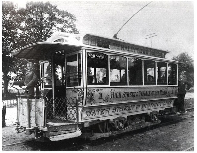
Conductor Terrance Sellers on the open platform of car No. 1 of the Georgetown & Tenallytown Street Railway.

The Georgetown and Tenallytown car barn, on the east side of Wisconsin Avenue at Calvert Street, had a coal fired steam power plant. The photograph was taken in 1909, when the barn was superseded by the Harrison Street Yard. By 1914 it had––in the way of all disused frame buildings in those days––burned down.

Although the name Tunlaw Heights actually refers to the subdivision immediately north of Glover Park, the name was loosely applied to a larger area. This 1916 photograph appears to have been taken near the present intersection of Huidekoper Place and W Street; along the horizon, from left to right, are Holy Rood Cemetery, the Vogt farm at the southern end of Tunlaw Road, a sprinkling of houses on the south slope of the cemetery, Western High School, and the House of the Good Shepherd.
The Industrial Home School
Georgetown’s Poor and Workhouse was taken over by the District of Columbia in 1875, and a new institution took up residence: the Industrial Home School. This institution had its origins in the Civil War, which had attracted many newcomers to the capital city to do war work; these people also had a penchant for relief work, charity, and reform. Washington, not widely known for progressive charity, was ripe for their efforts. One problem that attracted the attention of these reformers was that of homeless newsboys. Over time its mission was extended to orphans and truants.

The Industrial Home School, circa 1946.
In 1954 the residents of the Industrial Home School were transferred to the Children’s Center in Laurel, Maryland. The main building of the Industrial Home School, with its remnants of the 1832 Georgetown Poor House, was razed. Of an institution that had come into being during the Civil War to improve the lives of homeless newsboys, nothing is now to be seen but its dignified 1902 schoolhouse, which is now the Guy Mason Recreation Center.

The Industrial Home School, 1950; in the foreground, the future Guy Mason Recreation Center; at left, the girls’ residence; at right, a swimming pool, now on the grounds of the Naval Observatory.
The National School Of Domestic Arts and Science

Mary Arline Zurhorst (1878-1926)
The National School of Domestic Arts and Science was an ingeniously-conceived institution in which young women were to receive practical instruction––and be trained to instruct others––in home economics.
The school’s founder and principal was Mary A. Zurhorst; her business partner, Charles Francis Wood, was its architect. The design was on a grand scale, and was extensively covered in the press in 1915. Zurhorst and Wood envisioned a school where young women would learn to keep house in eleven communal residences while attending classes in home economics, interior decoration, music, languages, and elocution. The campus would have greenhouses and conservatories overlooking Wisconsin Avenue, and tennis courts at the back of the property for the students’ recreation.
A combination of unrealistic projections and architectural overreach––together with the entry of the United States into the First World War in 1917, and a sudden abundance of jobs for young women––appear to have caught Zurhorst and Wood off-balance. The project was drastically scaled back––only five of eleven buildings were built––and within months of its opening the school was being put to use as an inn (which lasted less than two years).
Mount Alto Veterans Hospital
When the National School Of Domestic Art and Science––and then the Mount Alto Inn––failed, the federal government purchased the facility, and converted it to use as a public health service hospital for veterans. The Mount Alto Veterans Hospital remained in operation until 1965, when it was succeeded by the embassy of the Soviet Union.

Mount Alto Veterans Hospital, 1950.
Residential Development Continues
A key event in the residential development of the neighborhood was the 1907 auction sale of land accumulated by Henry Kengla, a 91 year-old butcher who had lived alone at what is now 2400 Tunlaw Road.

The future Glover Park: to the north, the older subdivisions, Wesley Heights and Tunlaw Heights; to the west, Ridge (now Foxhall) Road. Arizona Avenue is the road that was intended to run in the bed of Foundry Branch, in Glover-Archbold Park. The property marked “V.C.Huidekoper” is Northwest Highlands, now Whitehaven Park. The numbered “H.K.” properties along Back Street (Tunlaw Road) became Observatory Heights.

Map of Property of Henry Kengla, Deceased, 1906 (overlaid on Google maps by Robert J. Carlson).
The 104-acre Kengla estate extended from Tunlaw Road to Foxhall Road. The greater part was purchased by banker Charles Carroll Glover, and not immediately developed. “The acreage property in the extreme northwestern section of Georgetown belonging to the estate of the late Henry Kengla was sold at public auction on Thursday, the purchaser being Charles C. Glover, and the consideration nearly $60,000.” Approximately 84 acres were purchased by Glover, who was not in any hurry: “Mr. Glover, it is understood, made the purchase on speculation.” (“Georgetown Land, $701.50 An Acre”, Washington Times, May 26, 1907, Sports-Real Estate, p.7)

Charles C. Glover, president of Riggs Bank, circa 1905,
In 1911 Glover increased his stake in the neighborhood. “Suburban Tract Sold to Glover––Banker Increases Holdings of Country Realty.––A further increase in the already immense holdings of President C.C. Glover, of the Riggs National Bank, is recorded in the transfer of a tract of more than twenty acres, bounded by Tunlaw road and Arizona avenue, directly south of Massachusetts avenue extended and west of Wisconsin avenue (Tennallytown road). The price paid by Mr. Glover for this extensive tract of valuable suburban land has not been expressed in the deed transferring it to him. The sale was made by J. Eakin Gadsby, for the estate of Henry Kengla.” (Washington Herald, May 4, 1911, p.12)
While the banker Glover could afford to bide his time, others could not. An attempt was made in 1909 to develop seven and a half acres of the Kengla estate on the west side of Tunlaw Road with a name that would capitalize on the prestige of a nearby landmark: Observatory Heights. But the name of this subdivision was quickly forgotten, as was the subdivision called Northwest Highlands, which is now Whitehaven Park.

Frederic Wolters Huidekoper, the developer of Burleith and of Northwest Highlands.
Other projects were more successful. As early as 1903, Phillip T. Hall––whose name is preserved in the name of Hall Place––had built his house on Wisconsin Avenue, south of W Place. In 1909 Hall’s land north of W Place became Lewis Breuninger’s Subdivision. Construction of Hall Place began in 1911. Numerous other houses were built along Wisconsin Avenue, on 37th Street, and on Tunlaw Road between 1903 and 1925.

Just completed houses on Hall Place in 1911.
In 1924, Charles C. Glover gave the newly instituted National Capital Parks Commission seventy-seven acres in the valley of Foundry Branch, which––with the addition of twenty-eight acres from Anne Archbold––became Glover-Archbold Park. Two years later, Glover turned eighty, and readers of Washington newspapers began to see advertisements for a new residential neighborhood honoring the banker and philanthropist’s name.

(Washington Post, November 24, 1926, p.2)
Glover Park Is Born
The earliest advertisements of Glover Park were placed by Benjamin H. Gruver in 1926. To ensure the success of this project Gruver employed George T. Santmyers, one of the most prolific architects of residential buildings in the metropolitan area. The firm, which had built houses in Petworth, Brightwood and Cleveland Park, rode out the Great Depression by concentrating on the development of Glover Park.
Charles and William Cooley––whose involvement in the development of Glover Park can be dated to about 1931––built their “English village” group and semi-detached houses in “Glover Park Heights”––at 39th, 40th, Benton and Beecher streets. Members of the two family firms merged in 1946 to form Gruver Cooley Construction, which is still in business today.

(Sunday Star, September 19, 1926)

(Washington Post, October 14, 1928)

The gang at Hall Place, circa 1928: In front, “Heavy” Robinson, Tommy Quinn, Billy Freeman, Johnny Ballinger, Clayton Snyder, Freddy Brault, Larry Duvall, Ken Murayama, Toddy Lyddane, and Buck Eby; in back, Eugene T. Lyddane and Louis Freeman.

B.H.Gruver promotional brochure, circa 1930

Glover Park was a mere six years old when its status as a full-fledged neighborhood was confirmed; Benjamin Stoddert Elementary School was dedicated on November 7, 1932.
On the day before the dedication, John Clagett Proctor, the Washington Star’s estimable historian, wrote a Sunday feature to acquaint his readers with Benjamin Stoddert, one of the founding fathers of the District of Columbia––and to regret that Stoddert’s august name had not been saved for a more important building.

Benjamin Stoddert Elementary School in 1994.
Apartments
After 1942, the bulk of all the housing added in Glover Park has been in the form of apartment buildings.
As early as 1917 the apartment segment of the market had begun to be addressed by “The Observatory”, at Wisconsin Avenue and Hall Place. The ground floor of this corner building featured space that would be for lease to a drug store that would have “No Competition in This Neighborhood”.

(“Well-known Washington Apartment Houses”, Washington Post, September 9, 1917, p.R3)

2209-23 40th Street. “Each apartment is well finished, has automatic heat and a screened in sleeping porch.” (“New Buildings Are Completed In Glover Park”, Washington Post, August 2, 1936, p.R1)

Apartments rented for $59.50 and up at the Weaver Brothers’ new “Fireproof Garden Court Apartments” at Tunlaw Road and Davis Place. (Washington Post, August 24, 1940)

When John P. Wymer took this picture, on June 25, 1950, Carillon House––the first hotel apartment building in Washington with central air conditioning––was still under construction.
Community Gardens
The Glover-Archbold Park Community Garden is prominently located southwest of the intersection of 42nd Street and Tunlaw Road, while the Whitehaven Community Garden is hidden from view, south of the intersection of W Street and 39th Place.
These two community gardens at the fringes of Glover Park originated in World War II, when Americans raised nearly forty percent of the nation’s produce in victory gardens.
One of the victory garden “pioneers” of 1941 was Alfred A. Goldschmidt, a retired German Jewish banker who had fled Hitler’s regime. Goldschmidt and his wife Camilla lived at 4122 Edmunds Street, in the Park View Terrace apartments, overlooking the 42nd Street victory garden.

Alfred Goldschmidt (right), one of the founders of the victory gardens in Glover Park, with Frank Roczey, of 4027 Beecher Street, president of the Glover Park Community Garden Association. (Washington Post and Times Herald, May 14, 1956)
________________________________________________________
Carlton Fletcher
The citation and acknowledgement of my research is greatly appreciated.
All rights reserved.
Questions and corrections may be directed to
The support of the Advisory Neighborhood Council (3B) is gratefully acknowledged.